Classroom example GHGSat
Show your class · 1 of 5
The questionShow your class · 2 of 5
How it worksShow your class · 3 of 5
Who does this workShow your class · 4 of 5
Ways inShow your class · 5 of 5
Ask the classFor you
About GHGSatFor you
SourcesHow can you find an invisible gas from space?
GHGSat · Lists a Calgary office. Headquarters in Montreal.
Where it fits
Pick your class- Physics 30 · Electromagnetic radiation
- Science 30 · Electromagnetic energy and environmental topics
- Science 10 · Global energy systems, as a broader introduction
How it works
Schematic · not to scale
Measuring methane with reflected sunlight
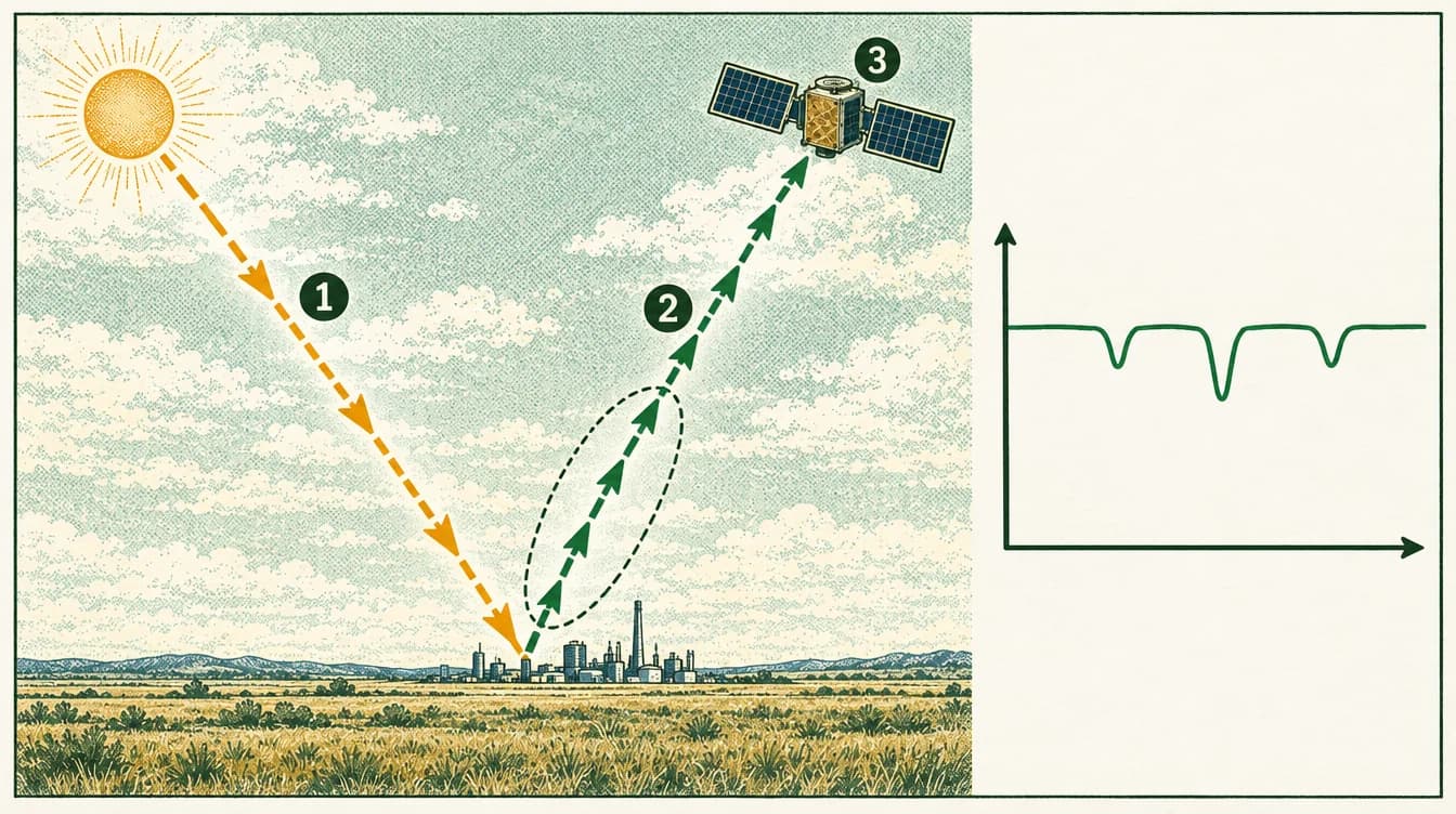
Sunlight travels down to the ground, including infrared we can’t see.
Reflected sunlight travels back up through the air toward the satellite.
A spectrometer splits the received light by wavelength. It sends out no light of its own.
Methane is invisible; the dashed outline marks its location. The graph shows light received vertically and wavelength horizontally: absorption makes dips, not zero light.
Methane measurement band: about 1,630–1,675 nanometres. Satellite altitude: about 500 km.
The lesson, in the real world
The physics of light lets a satellite about 500 km up measure a gas no one can see.
- 1
Sunlight contains many wavelengths, including shortwave infrared light our eyes can’t see.
- 2
Methane absorbs some of that light at particular wavelengths, between about 1,630 and 1,675 nanometres.
- 3
The satellite’s spectrometer measures sunlight scattered back up from the ground. It sends out no light of its own.
- 4
Where methane is present, a little less light arrives at those wavelengths. Analysts combine that dip with wind data to estimate how fast gas is escaping.
Our explanation
Who does this work
Role
Atmospheric science and remote sensing
Turn light measurements into an explanation of what is in the air.
Atmospheric and remote sensing scientists study how light travels through the air and what it can reveal. In methane monitoring, they decide whether a signal is real, estimate how much gas it represents, and say how certain they are.
What might you actually do?
Check the signal
Decide whether a measurement is reliable, or caused by something else such as cloud or a bright surface.
Build an estimate
Use models and wind information to turn an absorption signal into a rate of emission.
Share the findings
Explain results, and their uncertainty, to people who make decisions.
Typical of this kind of work in general. Not a description of any one person’s job at GHGSat.
- Often works with
- Satellite engineersData engineersIndustry specialistsCustomers
- Classroom connection
- Wavelength, absorption and measurement uncertainty all show up in this work.
Related job postings
Similar work at other employers in Calgary, AB, not openings at GHGSat. These are live searches: results change daily and we have not checked them.
- Atmospheric scientistIndeed search for Atmospheric scientist (opens in a new tab)Job Bank search for Atmospheric scientist (opens in a new tab)
- Remote sensing scientistIndeed search for Remote sensing scientist (opens in a new tab)Job Bank search for Remote sensing scientist (opens in a new tab)
- Environmental data scientistIndeed search for Environmental data scientist (opens in a new tab)Job Bank search for Environmental data scientist (opens in a new tab)
Saved job examples
How employers have described this kind of work, saved on the date shown. Employers have not reviewed or endorsed this page.
How to prepare
Earth Sciences major (BSc)
University of Alberta, Faculty of Science
Geomatics Engineering (BSc)
University of Calgary, Schulich School of Engineering
Ways in
For your students
Ways to prepare for this work
Programs that teach skills this work uses. Each is one route in, not a requirement, and no program has endorsed this page.
Showing routes for atmospheric science and remote sensing. Show all
University of Alberta, Faculty of ScienceUniversity degreeEdmonton
Earth Sciences major (BSc)
The Earth’s structure and evolution, and the atmosphere above it. Careers the page lists include meteorologist, global change researcher and research scientist.
Why it connects to the work · our interpretation
Atmospheric science and remote sensingThe program explicitly includes study of the atmosphere, the part of the Earth this measurement work is about.
University of Calgary, Schulich School of EngineeringUniversity degreeCalgary
Geomatics Engineering (BSc)
Collecting, modelling, analyzing and managing spatial data. Courses include remote sensing, satellite positioning and digital imaging.
Why it connects to the work · our interpretation
Atmospheric science and remote sensingIt teaches remote sensing, and the page asks how satellite images can be used to observe climate change.
Ask the class
Use it in class
Ask the class
If a sensor detects no methane, does that prove none is present? What would you want to know about the instrument and the observation conditions?
Detecting a gas, estimating how much is escaping, and deciding what to do are different tasks. Instruments, analysis and the people interpreting results all contribute.
Mindset it shows
Understand measurement limits before drawing conclusions.
About GHGSat

Measuring methane emissions from space, and from aircraft.
- Local connection
- Lists a Calgary office on 5th Avenue SW, one of five offices. The company does not say which teams work there.
- Source: GHGSat: Offices(opens in a new tab); GHGSat: About us(opens in a new tab)
- Team size
- More than 100 people. The About page says 150+ across five offices; the Team page says 100+ (both September 2026).
- Source: GHGSat: About us(opens in a new tab); GHGSat: Our team(opens in a new tab)
- The problem
- Methane leaks from industrial sites are invisible and were mostly self-reported. GHGSat says that when it started in 2011, 75% of industrial emissions had no independent monitoring.
- Source: GHGSat: About us(opens in a new tab)
- What they do
- Measurements of methane at the level of a single site, turned into emission rates that people can act on.
- Source: GHGSat home page(opens in a new tab); GHGSat: Technology(opens in a new tab)
- Who uses it
- Oil and gas operators, landfills, mining, agriculture, governments and financial institutions, according to the company.
- Source: GHGSat home page(opens in a new tab)
GHGSat describes itself as a greenhouse gas emissions intelligence company. It uses its own satellites and aircraft to measure methane from industrial sites around the world. It says it has launched 16 satellites.
Source: GHGSat home page(opens in a new tab); GHGSat: Satellite constellation(opens in a new tab)Read each source’s date and scope: a documented role is not proof of a current vacancy or of where every position is based.
Reported as GHGSat states it. GHGSat has not reviewed or endorsed this page.
Recent development
Free with signupGHGSat plans a second-generation satellite for early 2028
Published 21 Sep 2026 · Company announcement
Sources and course fit
Sources checked 24–29 Sep 2026
Where it fits
- Physics 30 · Electromagnetic radiation
- Science 30 · Electromagnetic energy and environmental topics
- Science 10 · Global energy systems, as a broader introduction
Editorial mapping to published CBE course topics. Pending educator review. No outcome-code alignment is claimed.
Sources
- GHGSat offices and work areas(opens in a new tab)
- Satellite technology(opens in a new tab)
- Second-generation satellite announcement, 21 Sep 2026(opens in a new tab)
- CBE Physics 20–30 topics(opens in a new tab)
- CBE Science 10–30 topics(opens in a new tab)
- UCalgary engineering physics(opens in a new tab)
- UCalgary engineering programs(opens in a new tab)
Organization claims are reported as the organization states them. GHGSat has not reviewed or endorsed this page.
What we know, and how
| Type | Claim | How we know |
|---|---|---|
| work | Satellite instruments measure methane, with a spectrometer at their heart.Source: Satellite technology | Company-stated |
| roles | Satellite engineering, atmospheric science, software, data science, commercial.Source: GHGSat offices and work areas | Observed · not vacancies |
| pathways | Physics, engineering, computing and data study.Source: UCalgary engineering physics | Inferred direction |
| news | A second-generation satellite is planned for early 2028.Source: Second-generation satellite announcement, 21 Sep 2026 | Projected · not operating |
| course fit | Physics 30, Science 30, Science 10.Source: CBE Physics 20–30 topics; CBE Science 10–30 topics | Editorial · pending review |
Solid green: the organization states it. Outlined: seen in a dated source. Dashed: our interpretation, not yet researched, or announced but not yet real.