Classroom example GeologicAI
Show your class · 1 of 5
The questionShow your class · 2 of 5
How it worksShow your class · 3 of 5
Who does this workShow your class · 4 of 5
Ways inShow your class · 5 of 5
Ask the classFor you
About GeologicAIFor you
SourcesWhat can a rock scan tell us that our eyes cannot?
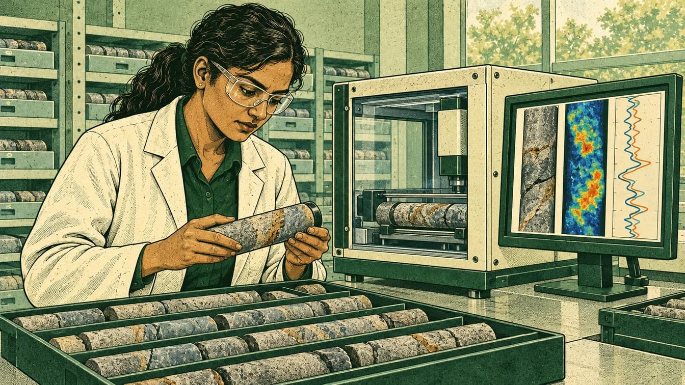
GeologicAI · Calgary office and company development team; scanning and field operations also occur at customer sites internationally.
Where it fits
Pick your class- Science 20 · Earth materials and evidence
- Physics 30 · Electromagnetic radiation and measurement
How it works
Schematic · not to scale
A scan is evidence to interpret
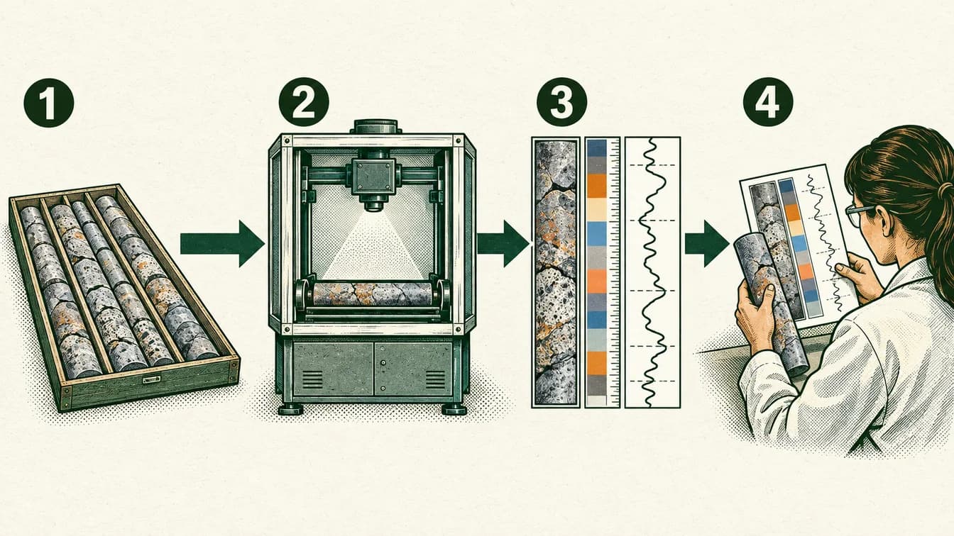
Keep track of the rock sample and its position.
Collect measurements with scanning instruments.
Align different measurements of the same core.
Compare patterns with geological observations and further tests.
No particular mineral, grade or resource estimate is established by this illustration.
The lesson, in the real world
The same rock can be measured in several different ways.
- 1
Drill core is a physical sample from a particular place and depth. Its location and handling matter to interpretation.
Our explanation - 2
Different sensors measure different properties: images show appearance, while other measurements add chemical, spectral or geometric information.
Our explanation - 3
Software aligns the information so a geoscientist can compare patterns along the core. Interpretation still depends on context and validation.
Our explanation - 4
A model extends beyond directly sampled material. New measurements can test the model and change confidence in it.
Our explanation
Who does this work
Role
Instrument development and testing
Help build and check the equipment that produces measurements. Instrument work joins hardware, software and experiments rather than treating a reading as automatically correct.
What might you actually do?
Investigate
Check performance using a known reference.
Test and compare
Investigate drift, noise or inconsistent readings.
Explain and improve
Document tests so later users know what the instrument can establish.
Typical of this kind of work in general. Not a description of any one person’s job at GeologicAI.
- Often works with
- Scientists, electronics specialists and software developers
- Classroom connection
- Measurement uncertainty is part of using a tool responsibly.
Related job postings
Similar work at other employers in Calgary, AB, not openings at GeologicAI. These are live searches: results change daily and we have not checked them.
How to prepare
Geomatics Engineering Technology
SAIT
Ways in
For your students
Ways to prepare for this work
Programs that teach skills this work uses. Each is one route in, not a requirement, and no program has endorsed this page.
Showing routes for instrument development and testing. Show all
SAITDiplomaCalgary
Geomatics Engineering Technology
Learn surveying, GIS, positioning and remote sensing.
About this route
Check the provider’s current prerequisites and intake availability. This is a related learning route, not a hiring promise or an employer requirement.
Why it connects to the work · our interpretation
Instrument development and testingSupports spatial measurement and mapping data work. Measurement uncertainty is part of using a tool responsibly.
Ask the class
Use it in class
Ask the class
If a model is very detailed, does that mean it is well supported everywhere?
Give students a fictional strip of core with visible colour changes and a second strip of sensor readings. Ask where they would collect an additional sample and what it would test.
Mindset it shows
The strongest answer identifies a specific uncertainty. Do not equate a sensor count with an independently verified mineral concentration.
About GeologicAI

The same rock can be measured in several different ways.
- Headquarters
- Calgary office and company development team; scanning and field operations also occur at customer sites internationally.
- Source: Sensors, teams and location(opens in a new tab); Current careers page(opens in a new tab); Dated technology specification(opens in a new tab)
- Local connection
- Calgary office and company development team; scanning and field operations also occur at customer sites internationally.
- Source: Sensors, teams and location(opens in a new tab); Current careers page(opens in a new tab); Dated technology specification(opens in a new tab)
- Team size
- Not verified. We have not found a dated, sourced figure.
- The problem
- How can several measurements improve an interpretation of a rock sample?
- Source: Sensors, teams and location(opens in a new tab); Current careers page(opens in a new tab); Dated technology specification(opens in a new tab)
- What they do
- Core scanning, digital logging, analytical tools and resource-modeling services.
- Source: Sensors, teams and location(opens in a new tab); Current careers page(opens in a new tab); Dated technology specification(opens in a new tab)
- Who uses it
- Geoscientists and resource teams interpreting samples and planning further work.
- Source: Sensors, teams and location(opens in a new tab); Current careers page(opens in a new tab); Dated technology specification(opens in a new tab)
GeologicAI develops core-scanning and data tools for resource work and lists a Calgary location. Its system combines measurements such as visible images, X-ray fluorescence, hyperspectral sensing and geometric data. These provide different kinds of evidence for interpreting drill core and building geological understanding.
Source: Sensors, teams and location(opens in a new tab); Current careers page(opens in a new tab); Dated technology specification(opens in a new tab)Read each source’s date and scope: a documented role is not proof of a current vacancy or of where every position is based.
Reported as GeologicAI states it. GeologicAI has not reviewed or endorsed this page.
Sources and course fit
Sources checked 15 Oct 2026
Where it fits
- Science 20 · Earth materials and evidence
- Physics 30 · Electromagnetic radiation and measurement
Editorial mapping to published CBE course topics. Pending educator review. No outcome-code alignment is claimed.
Sources
- Alberta Physics 20–30 performance standards(opens in a new tab)
- SAIT — Software Development(opens in a new tab)
- Calgary Board of Education: Science 10/20/30 course topics(opens in a new tab)
- SAIT — Geomatics Engineering Technology(opens in a new tab)
- Sensors, teams and location(opens in a new tab)
- Current careers page(opens in a new tab)
- Dated technology specification(opens in a new tab)
- University of Calgary — Geology(opens in a new tab)
Organization claims are reported as the organization states them. GeologicAI has not reviewed or endorsed this page.
What we know, and how
| Type | Claim | How we know |
|---|---|---|
| work | GeologicAI develops core-scanning and data tools for resource work and lists a Calgary location. Its system combines measurements such as visible images, X-ray fluorescence, hyperspectral sensing and geometric data. These provide different kinds of evidence for interpreting drill core and building geological understanding.Source: Sensors, teams and location; Current careers page; Dated technology specification | Organization-stated |
| local connection | Calgary office and company development team; scanning and field operations also occur at customer sites internationally.Source: Sensors, teams and location; Current careers page; Dated technology specification | Organization-stated |
| course fit | Combine geological observations with sensor evidence. X-ray and hyperspectral methods extend electromagnetic-radiation ideas; a scan does not establish an entire deposit.Source: Calgary Board of Education: Science 10/20/30 course topics; Alberta Physics 20–30 performance standards | Editorial connection to verified course topics |
| limits | A search-indexed software posting returned Page Not Found from the original URL; it is excluded as current job evidence. Current careers list includes an overseas field role; it must not be relabelled Calgary. Do not claim AI removes the need for geological judgment or laboratory validation.Source: Sensors, teams and location; Current careers page; Dated technology specification | Scope of this example |
Solid green: the organization states it. Outlined: seen in a dated source. Dashed: our interpretation, not yet researched, or announced but not yet real.